Last week Quixote wrote a post about her observations while taking a walk in Southern California. If you missed that post, please be sure to check it out?
An orange-brown band of dust? smog? all of the above? stretching over the whole horizon. There?s a larger composite picture here that shows more of the extent. (In the foreground, you can make out the Navy Seabees target practice range. That?s Anacapa Island shrouded in the distance.)
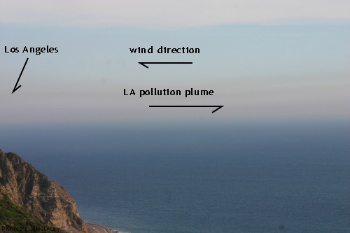
I?ve lived here for years and never seen anything like it. Ordinary Los Angeles pollution looks like this:
It?s more purple-colored, much fainter, and bigger toward LA, petering out toward the ocean. (The picture is from an old post where I was puzzling about wind direction.)
When I mentioned it at home, I found out that Beijing had an Airpocalypse around January 12th and the next few days, an immense pollution event that drowned the city in choking dusty smog.
There was a new article published today that discusses this very thing. ?Off-the-scale? smog envelops Beijing and northern China
Pollution levels in Beijing soared above index limits, the US embassy said, as a dense cloud of haze shrouded large swathes of northern China.
People in the capital, some wearing masks, Tuesday battled through a second consecutive day of pollution at hazardous levels. Beijing municipal authorities warned those with respiratory difficulties to stay indoors.
It is at least the fourth time a dense cloud of haze has descended on northern China this winter, reducing visibility and causing flight delays, with even state media repeatedly expressing anger over the issue.
?The current environmental problems are worrisome,? Wang Anshun, who took over as mayor of the Chinese capital this week, was quoted as saying by the official Xinhua news agency.
The US embassy?s air quality index (AQI) reading for Beijing stood at 495 and ?hazardous? at 11am, after reaching 517, or ?beyond index?, at 6am.
The index rates anything over 150 as ?unhealthy?, over 300 as ?hazardous?, while a reading above the upper limit of 500 is regarded as ?beyond index?.
Meanwhile, the Beijing Municipal Environmental Monitoring Centre gave the figure at 10am as 393, indicating the air in the capital was ?severely polluted?.
The toxic air follows an extreme bout of pollution earlier this month, peaking on January 13 when state media said readings for PM 2.5, particles small enough to deeply penetrate the lungs, reached 993 micrograms per cubic metre, almost 40 times the World Health Organisation?s recommended safe limit.
On another weather related article, many of you may be in the path of this bad weather event, so keep up with the forecast in your area: Unusual January warmth triggers severe storms in US South
A very large and potent weather system is developing across the U.S. central plains today. The system will advance eastward to provide a large portion of the eastern United States a chance to see strong to severe thunderstorms Tuesday and Wednesday.
The cold front is very strong, as temperatures are nearly 20 to 30 degrees cooler behind the front. Ahead of the front, unusually warm temperatures are pushing northward with dew points in the upper 50?s and low to mid 60?s. With plenty of moisture and warm temperatures in place, thunderstorms that develop across this region will be able to use this energy as fuel to help intensify. If you live in Missouri, Indiana, Illinois, Arkansas, Kentucky, Louisiana, Tennessee, Mississippi, Alabama, Georgia, South Carolina, and North Carolina, you need to be prepared for the possibility of damaging winds and isolated tornadoes Tuesday and Wednesday as this storm sweeps to the east.
The Storm Prediction Center (SPC) has issued a moderate risk for severe weather for northern Louisiana, Arkansas, northwest Mississippi, and southeast Missouri. Meanwhile, a slight risk has been issued for the states surrounding the moderate area:
Categorical outlook issued for January 29, 2013. Image Credit: SPC
There is an enhanced tornado threat for Tuesday, January 29, 2013. The map below shows the probability of a tornado within 25 miles of a point. The hatched Area (black dashes) indicate a 10% or greater probability of EF2 ? EF5 tornadoes within 25 miles of a point. Most of Arkansas is in a 15% hatched area, which is very high.
")

This new storm is a result of two air masses?
Warm air ahead of the front will help fuel the thunderstorms that develop across the Southeast Tuesday and Wednesday. Image Credit: Weatherbell
When you look at the large picture, it is pretty obvious that straight line winds will be the main threat with this system as a squall line, also called a QLCS, or Quasi linear convective system, pushes eastward. There are concerns that discrete cells could develop ahead of the front, which would be the area prone to see the strongest tornadoes. The region most likely to see supercells will be the areas within the moderate risk area today. There is plenty of wind shear, or change in wind speed or direction with height, in the atmosphere associated with this strong cold front. No doubt that as this front pushes eastward, the momentum will be transferred to the surface where winds could easily gust to 60 to 70 miles per hour. Squall lines can produce widespread damage, so everyone in the highlighted areas noted on the SPC Day 1 and 2 outlook should be weather aware as this system pushes into your area. As this line advances east, there is no doubt the severe thunderstorm watches or tornado watches will be issued in advanced to prepare people for the upcoming storms. If you live in the area where this line of storms can sweep through, you might want to bring in any loose objects that are sitting outside that could be picked up by the wind and be used as flying debris.

Keep a watch out and take care.
This is an open thread.
Did you like this post? Please share it with your friends:
Source: http://skydancingblog.com/2013/01/29/evening-news-reads-smog-and-weather-open-link/
tomb of the unknown soldier tomb of the unknown soldier HMS Bounty dominion power Heather Clem Con Edison LaGuardia Airport
No comments:
Post a Comment
Note: Only a member of this blog may post a comment.